

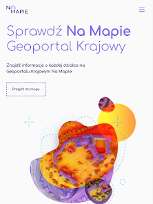
Geoportal Krajowy Na Mapie

50K+
Downloads

Everyone
info

About this app
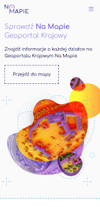
The National Geoportal Na Map was created so that everyone has free access to maps containing basic information about the area in which they own or invest in real estate.
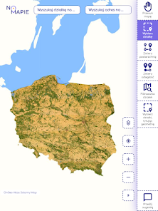
The National Geoportal is a service thanks to which you can quickly obtain information on the map about any plot and its surroundings. The presented maps present data from public registers in an unprecedented form, all thanks to the involvement of an experienced team of specialists and the use of open spatial data.
The portal and the application for computers are available at: https://geoportal-krajowy.pl.
The National Geoportal On Map collects data such as:
- registration plots,
- buildings,
- addresses,
- solar potential,
- terrain relief,
- names and boundaries of towns,
- roads, railways,
- green areas,
- watercourses and reservoirs,
- current orthophotomap,
- orthophotomap of 1944
- aerial photos ,
- and much more.
Available tools in the National Geoportal On the Map:
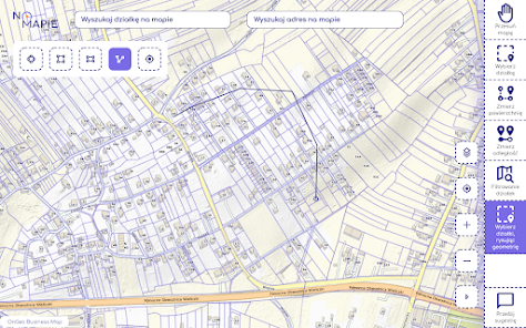
- Record plot search engine, allows you to search for a plot on the map, after entering the plot number and the name of the commune, town.
- Address finder, allows you to find addresses on the map.
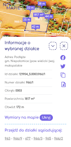
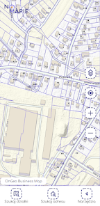
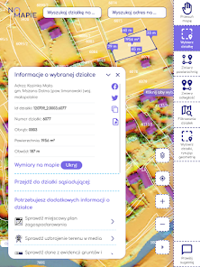
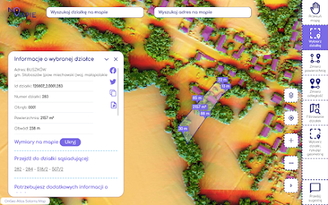
- Identification of the record plot, after clicking on the map area, you will get a complete set of information about the record plot, including: plot number, plot ID, precinct number, area, perimeter, province, poviat, commune, address.
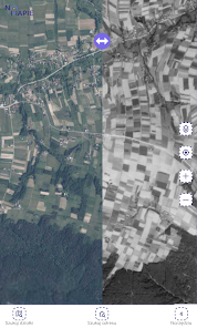
- Comparing maps, the ability to compare two selected map compositions, including the current orthophotomap with the orthophotomap from 1944 (for the Podkarpackie Voivodeship).
- Archival Aerial Photo Report tool, thanks to which you can check how a given plot was developed in different years.
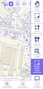
- GPS location, information about the current position of the application user on the map.
- Automatic plot measurement, after selecting a plot on the map, it will be highlighted and the dimensions of each section of the plot border will appear, in the central part of the selected plot, the plot area will be displayed.
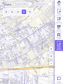
- Area measurement on the map, after selecting the tool, by clicking on the selected area of the map, we measure the area.
- Distance measurement on the map, after selecting the tool, by clicking on the selected place on the map, we measure the distance.
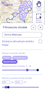
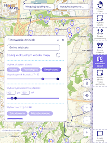
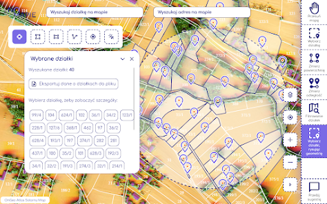
- Filtering plots, the tool allows you to search for a plot by many parameters, such as plot area, plot shape, existence of buildings on the plot. This tool can be useful in cases where we do not know the plot number and exact location, but we know the parameters characterizing the plot.
Maps available in Geoportal:
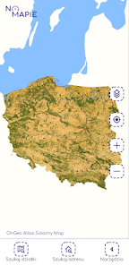
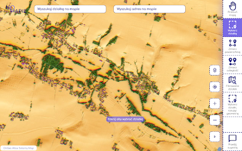
- Satellite Map / Orthophotomap, made on the basis of aerial photos. Thanks to the data from the orthophotomap, you can easily verify the development status of the plot.
- The Atlas-Solar map shows the space around us in an unprecedented way. Thanks to the Solar Atlas map, you can check the area you are interested in on the map. You will find out what is the neighborhood of your plot, what is the relief and insolation of the area. You can easily determine the solar potential on the plot. You will learn how the boundaries of the plot and basic information from official registers run.
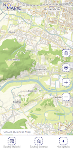
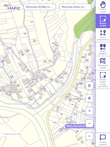
- Geo Map, is a basic map, it shows a full range of geographic information. Geo Map presents mainly: borders and numbers of cadastral plots, 3D buildings, borders of towns, streets and addresses, legible symbolization of road networks, relief and land cover
Thanks to the Interactive Geo Map, you will be able to easily find the information that interests you, which you will use, for example, to check the plot before buying it and for many purposes and types of activity
- Historical orthophotomap of 1944 for the area of the Podkarpackie Voivodeship. The map is available in the map comparison tool.
Project website: https://geoportal-krajowy.pl/
The National Geoportal is a service thanks to which you can quickly obtain information on the map about any plot and its surroundings. The presented maps present data from public registers in an unprecedented form, all thanks to the involvement of an experienced team of specialists and the use of open spatial data.
The portal and the application for computers are available at: https://geoportal-krajowy.pl.
The National Geoportal On Map collects data such as:
- registration plots,
- buildings,
- addresses,
- solar potential,
- terrain relief,
- names and boundaries of towns,
- roads, railways,
- green areas,
- watercourses and reservoirs,
- current orthophotomap,
- orthophotomap of 1944
- aerial photos ,
- and much more.
Available tools in the National Geoportal On the Map:
- Record plot search engine, allows you to search for a plot on the map, after entering the plot number and the name of the commune, town.
- Address finder, allows you to find addresses on the map.
- Identification of the record plot, after clicking on the map area, you will get a complete set of information about the record plot, including: plot number, plot ID, precinct number, area, perimeter, province, poviat, commune, address.
- Comparing maps, the ability to compare two selected map compositions, including the current orthophotomap with the orthophotomap from 1944 (for the Podkarpackie Voivodeship).
- Archival Aerial Photo Report tool, thanks to which you can check how a given plot was developed in different years.
- GPS location, information about the current position of the application user on the map.
- Automatic plot measurement, after selecting a plot on the map, it will be highlighted and the dimensions of each section of the plot border will appear, in the central part of the selected plot, the plot area will be displayed.
- Area measurement on the map, after selecting the tool, by clicking on the selected area of the map, we measure the area.
- Distance measurement on the map, after selecting the tool, by clicking on the selected place on the map, we measure the distance.
- Filtering plots, the tool allows you to search for a plot by many parameters, such as plot area, plot shape, existence of buildings on the plot. This tool can be useful in cases where we do not know the plot number and exact location, but we know the parameters characterizing the plot.
Maps available in Geoportal:
- Satellite Map / Orthophotomap, made on the basis of aerial photos. Thanks to the data from the orthophotomap, you can easily verify the development status of the plot.
- The Atlas-Solar map shows the space around us in an unprecedented way. Thanks to the Solar Atlas map, you can check the area you are interested in on the map. You will find out what is the neighborhood of your plot, what is the relief and insolation of the area. You can easily determine the solar potential on the plot. You will learn how the boundaries of the plot and basic information from official registers run.
- Geo Map, is a basic map, it shows a full range of geographic information. Geo Map presents mainly: borders and numbers of cadastral plots, 3D buildings, borders of towns, streets and addresses, legible symbolization of road networks, relief and land cover
Thanks to the Interactive Geo Map, you will be able to easily find the information that interests you, which you will use, for example, to check the plot before buying it and for many purposes and types of activity
- Historical orthophotomap of 1944 for the area of the Podkarpackie Voivodeship. The map is available in the map comparison tool.
Project website: https://geoportal-krajowy.pl/
Updated on
Safety starts with understanding how developers collect and share your data. Data privacy and security practices may vary based on your use, region, and age. The developer provided this information and may update it over time.

No data shared with third parties
Learn more about how developers declare sharing

No data collected
Learn more about how developers declare collection
What's new
Aktualizacja komponentów oprogramowania
App support
phone
Phone number
+48503392404


